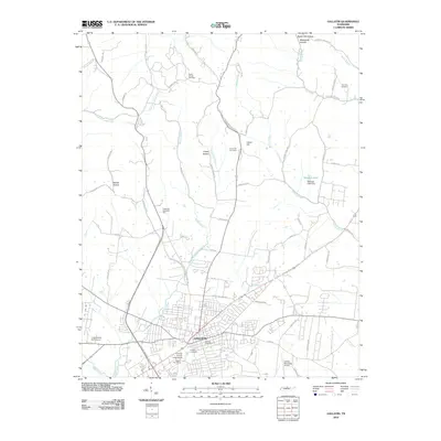
2010 Map of Gallatin
USGS Topo · Published 2010About this map
Gallatin serves as the focal point of this Sumner County landscape, where the convergence of Town Creek and East Camp Creek has historically shaped the local development pattern. The 2010 geography reveals a mix of civic infrastructure and rural tradition, featuring the Sumner County Fairgrounds and the Gallatin Post Office alongside well-established landmarks like the Gallatin Cemetery. To the north, the terrain transitions into the hollows and ridges of the Highland Rim, punctuated by the small settlement of Union Hill and its namesake Union Hill Cemetery. This area is characterized by family-named landscape features such as Brazier Hollow, Linsey Hollow, and Butler Mill Hollow, which reflect long-standing land divisions. Transportation routes like Old Dobbins No 2 Pike and Old Gallatin Rd trace the paths of historical travel between these rural uplands and the growing municipal center of the county seat.
Find a feature on this map
71 named features on this map. Tap any name to fly to it.
Don’t see what you’re looking for? This feature index may not catch every label — zoom into the map to look around manually.
Map Details
Editions of this 2010 Gallatin Map
This is the sole edition of this map. No revisions or reprints were ever made.
Other maps of this area

1903 · Nashville
USGS Topo · 1:125,000

1931 · Adolphus
USGS Topo · 1:62,500

1942 · Gallatin
USGS Topo · 1:100,000

1952 · Hendersonville
USGS Topo · 1:24,000

1953 · Cottontown
USGS Topo · 1:24,000

1955 · Bethpage
USGS Topo · 1:24,000

1955 · Laguardo
USGS Topo · 1:24,000

1955 · Hunters Point
USGS Topo · 1:24,000

1955 · Gallatin
USGS Topo · 1:24,000
1956 · Portland
USGS Topo · 1:24,000