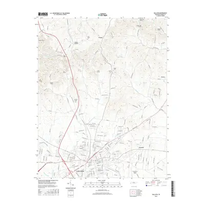
2016 Map of Gallatin
USGS Topo · Published 2016About this map
The city of Gallatin serves as the central hub of this 2016 survey, where the CSX Transportation line and several state routes converge. The landscape is characterized by its numerous named hollows, such as Buttermilk Hollow, Joel Hollow, and Brazier Hollow, reflecting a rugged topography that channels waterways like East Camp Creek and Deshea Creek toward the south. To the north, the small community of South Tunnel and the hamlet of Graball mark the transition toward more rural Sumner County terrain. Genealogists will find several notable burial sites recorded, including Gallatin Cem, Bushs Chapel Cem, and Union Hill Cem. The presence of the Sumner County Regional Airport and Crestview Memorial Park highlights the modern infrastructure expansion around the city’s perimeter. This map documents the persistent connection between the historic rail corridor and the evolving residential and industrial footprint of the region.
Find a feature on this map
174 named features on this map. Tap any name to fly to it.
Don’t see what you’re looking for? This feature index may not catch every label — zoom into the map to look around manually.
Map Details
Editions of this 2016 Gallatin Map
This is the sole edition of this map. No revisions or reprints were ever made.
Other maps of this area

1903 · Nashville
USGS Topo · 1:125,000

1931 · Adolphus
USGS Topo · 1:62,500

1942 · Gallatin
USGS Topo · 1:100,000

1952 · Hendersonville
USGS Topo · 1:24,000

1953 · Cottontown
USGS Topo · 1:24,000

1955 · Bethpage
USGS Topo · 1:24,000

1955 · Laguardo
USGS Topo · 1:24,000

1955 · Hunters Point
USGS Topo · 1:24,000

1955 · Gallatin
USGS Topo · 1:24,000
1956 · Portland
USGS Topo · 1:24,000