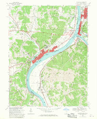
1968 Map of Gallipolis
USGS Topo · Published 1970About this map
The confluence of the Ohio River and Kanawha River serves as the focal point for this late 1960s study of the river valley. The riverfront towns of Gallipolis, Ohio, and Point Pleasant, West Virginia, are shown in detail, connected by the rail networks of the Baltimore and Ohio, Chesapeake and Ohio, and Penn Central. This area is characterized by its deep institutional and civic roots, evidenced by the sprawling campus of the Gallipolis State Institute and the Gallia Academy.
Find a feature on this map
101 named features on this map. Tap any name to fly to it.
Don’t see what you’re looking for? This feature index may not catch every label — zoom into the map to look around manually.
Map Details
Editions of this 1968 Gallipolis Map
This is the sole edition of this map. No revisions or reprints were ever made.
Other maps of this area

1906 · Bidwell
USGS Topo · 1:62,500

1906 · Athalia
USGS Topo · 1:62,500

1906 · Glenwood
USGS Topo · 1:62,500

1908 · Bidwell
USGS Topo · 1:62,500

1908 · Athalia
USGS Topo · 1:62,500

1908 · Glenwood
USGS Topo · 1:62,500

1908 · Point Pleasant
USGS Topo · 1:62,500

1926 · Point Pleasant
USGS Topo · 1:62,500

1929 · Point Pleasant
USGS Topo · 1:62,500

1957 · Beech Hill
USGS Topo · 1:24,000