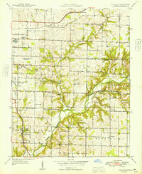
1948 Map of Galloway
USGS Topo · Published 1948About this map
The St Louis-San Francisco railway defines the industrial and transit corridor of this Greene County landscape, connecting the rural townships of Taylor and North Campbell. Near the settlement of Galloway, the Sequiota State Park and Sequiota Sch highlight a pocket of early conservation and community infrastructure. The map reveals a high density of one-room schoolhouses and country churches that served the agricultural population before post-war consolidation, including Oakland Sch, Pleasant Valley Sch, and Eastland Ch. Along the James River, the crossing at Mc Craw Ford and the Kinser Bridge show how local movement relied on traditional river access points. On the western edge, the Springfield Municipal Park and Airport and Springfield Airport Radio Station signal the encroaching modernization of the nearby city into the surrounding farmland.
Find a feature on this map
46 named features on this map. Tap any name to fly to it.
Don’t see what you’re looking for? This feature index may not catch every label — zoom into the map to look around manually.
Map Details
Editions of this 1948 Galloway Map
2 editions found
Other maps of this area

1884 · Springfield
USGS Topo · 1:125,000

1886 · Springfield
USGS Topo · 1:125,000

1935 · Springfield
USGS Topo · 1:24,000

1937 · Galloway
USGS Topo · 1:24,000

1937 · Ozark
USGS Topo · 1:48,000

1943 · Ozark
USGS Topo · 1:62,500

1945 · Ozark
USGS Topo · 1:62,500

1946 · Bassville
USGS Topo · 1:24,000

1947 · Strafford
USGS Topo · 1:62,500

1948 · Bassville
USGS Topo · 1:24,000