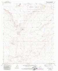
1973 Map of Gammil Well NE
USGS Topo · Published 1987About this map
Melrose Bombing Range occupies a significant portion of the northern landscape in this 1970s survey, defined by its clear Military Reservation Boundary. The terrain is characterized by the dramatic escarpment of The Mesa and the prominent Negrohead Butte, which overlook the winding path of Cañada del Tule. Ranching and aviation operations are evident through features like the Price-Portales Ranch, Price West Camp, and a remote Landing Strip. For those researching local family history, the Benson Cem stands as a notable landmark in the central valley. The map also records several scattered Wells and a network of Jeep Trails that provided access through this arid environment before modern development and revisions were documented in the late 1980s.
Find a feature on this map
14 named features on this map. Tap any name to fly to it.
Don’t see what you’re looking for? This feature index may not catch every label — zoom into the map to look around manually.
Map Details
Editions of this 1973 Gammil Well NE Map
2 editions found
Other maps of this area

1954 · Clovis
USGS Topo · 1:250,000

1957 · Melrose
USGS Topo · 1:62,500

1958 · Clovis
USGS Topo · 1:250,000

1973 · Lewiston Lake
USGS Topo · 1:24,000

1973 · Gammil Well SE
USGS Topo · 1:24,000

1973 · Tule Lake
USGS Topo · 1:24,000
1973 · Gammil Well
USGS Topo · 1:24,000

1973 · Gammil Well NE
USGS Topo · 1:24,000

1973 · Upton
USGS Topo · 1:24,000
1973 · Rippee Ranch
USGS Topo · 1:24,000