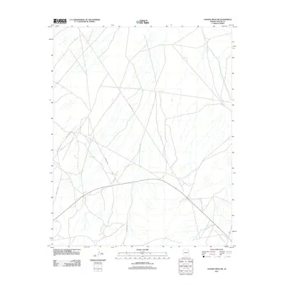
2011 Map of Ganado Mesa SW
USGS Topo · Published 2011About this map
The high desert plateau of the Fort Defiance Agency is defined by a intricate network of drainage channels and a sparse but vital transportation web. As a 2011 survey, this map captures the remote landscape of the Navajo Nation where tribal and county infrastructure intersect. Primary access through this arid terrain is facilitated by Indian Rte 25, which serves as a central artery for the region. The landscape is further etched by secondary paths such as Indian Rte 9052, Indian Rte 9053, and Indian Rte 9005, tracing the natural contours of the mesas. Near the southeast corner, the arrival of Co Rd 451 highlights the transition toward more established regional routes, illustrating how modern connectivity reaches into these traditional lands.
Find a feature on this map
5 named features on this map. Tap any name to fly to it.
Don’t see what you’re looking for? This feature index may not catch every label — zoom into the map to look around manually.
Map Details
Editions of this 2011 Ganado Mesa SW Map
This is the sole edition of this map. No revisions or reprints were ever made.
Other maps of this area

1886 · Fort Defiance
USGS Topo · 1:250,000

1892 · Fort Defiance
USGS Topo · 1:250,000

1954 · Gallup
USGS Topo · 1:250,000
1955 · Ganado 1 NE
USGS Topo · 1:24,000

1958 · Gallup
USGS Topo · 1:250,000

1959 · Gallup
USGS Topo · 1:250,000

1962 · Gallup
USGS Topo · 1:250,000

1967 · Gallup
USGS Topo · 1:250,000
1972 · Steamboat Canyon
USGS Topo · 1:24,000
1972 · Tolani
USGS Topo · 1:24,000