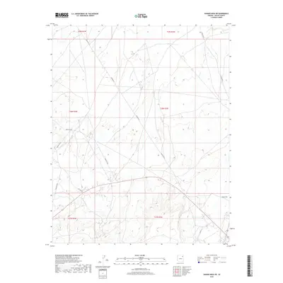
2018 Map of Ganado Mesa SW
USGS Topo · Published 2018About this map
Indian Rte 25 and Indian Rte 9052 form a network of travel ways across this high-desert landscape in Apache County, recorded by the U.S. Geological Survey in 2018. The terrain is defined by dramatic elevation changes, notably across Snake Flat, where the map's contour lines indicate a transition from higher mesas into broader basins. Seasonal drainage patterns are visible through labels like Bi-Keesh-Wash, which cuts through the northeastern corner of the quadrangle. This recent topographical study captures the contemporary layout of local transportation routes, including City Rd 318 and Co Rd 451, showing how modern infrastructure follows the natural topography of the Fort Defiance Agency region.
Find a feature on this map
13 named features on this map. Tap any name to fly to it.
Don’t see what you’re looking for? This feature index may not catch every label — zoom into the map to look around manually.
Map Details
Editions of this 2018 Ganado Mesa SW Map
This is the sole edition of this map. No revisions or reprints were ever made.
Other maps of this area
1886 · Fort Defiance
USGS Topo · 1:250,000
1892 · Fort Defiance
USGS Topo · 1:250,000

1954 · Gallup
USGS Topo · 1:250,000
1955 · Ganado 1 NE
USGS Topo · 1:24,000

1958 · Gallup
USGS Topo · 1:250,000

1959 · Gallup
USGS Topo · 1:250,000
1962 · Gallup
USGS Topo · 1:250,000
1967 · Gallup
USGS Topo · 1:250,000
1972 · Steamboat Canyon
USGS Topo · 1:24,000
1972 · Tolani
USGS Topo · 1:24,000