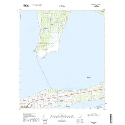
2021 Map of Garcon Point
USGS Topo · Published 2021About this map
Garcon Point and the surrounding coastal reaches of Santa Rosa County are defined by a complex geography of bays and sounds. The peninsula, jutting between Escambia Bay and East Bay, contains the small community of Dickerson City and the local airstrip at Garcon Field. To the north, the Black Hammock Cem sits near the marshy wetlands that characterize the interior of the point. Further south, across Pensacola Bay, the shoreline around Tiger Point shows denser modern development with residential layouts and proximity to the Gulf Islands National Seashore. This area is a vital maritime corridor, with the Intracoastal Waterway running through Santa Rosa Sound. Notable landforms like Hernandez Point and Redfish Point mark the winding coastline, while the Forty Mile Loop Trl provides a recreational path through the evolving landscape of the Florida Panhandle.
Find a feature on this map
111 named features on this map. Tap any name to fly to it.
Don’t see what you’re looking for? This feature index may not catch every label — zoom into the map to look around manually.
Map Details
Editions of this 2021 Garcon Point Map
This is the sole edition of this map. No revisions or reprints were ever made.
Other maps of this area

1920 · Milton
USGS Topo · 1:62,500

1921 · Holley
USGS Topo · 1:62,500

1921 · Pensacola
USGS Topo · 1:62,500

1934 · Harold
USGS Topo · 1:62,500

1936 · Holley
USGS Topo · 1:48,000

1937 · Harold
USGS Topo · 1:62,500

1938 · Holley
USGS Topo · 1:62,500

1938 · Harold
USGS Topo · 1:62,500

1941 · Pensacola
USGS Topo · 1:62,500

1941 · Milton
USGS Topo · 1:62,500