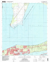
1994 Map of Garcon Point
USGS Topo · Published 2000About this map
Garcon Point and the surrounding marshlands of Santa Rosa County define this coastal landscape as it appeared in the mid-1990s. The northern peninsula is dominated by the Yellow River Marsh State Aquatic Preserve, where scattered landmarks like Black Hammock Cem and Wilson Memorial Ch sit near the northern boundary. To the south, across East Bay, the narrow strip of land between Redfish Cove and Santa Rosa Sound shows significant residential development. Established communities such as Oriole Beach and Woodlawn Beach are centered around local institutions like St Pauls Ch and Memorial Serenity Gardens. The presence of a Landing Strip and a Golf Course reflects the area's transition toward recreation and coastal living, while the Gulf Island National Seashore preserves the southernmost shoreline along the Intracostal Waterway.
Find a feature on this map
27 named features on this map. Tap any name to fly to it.
Don’t see what you’re looking for? This feature index may not catch every label — zoom into the map to look around manually.
Map Details
Editions of this 1994 Garcon Point Map
This is the sole edition of this map. No revisions or reprints were ever made.
Other maps of this area

1920 · Milton
USGS Topo · 1:62,500

1921 · Holley
USGS Topo · 1:62,500

1921 · Pensacola
USGS Topo · 1:62,500

1934 · Harold
USGS Topo · 1:62,500

1936 · Holley
USGS Topo · 1:48,000

1937 · Harold
USGS Topo · 1:62,500

1938 · Holley
USGS Topo · 1:62,500

1938 · Harold
USGS Topo · 1:62,500

1941 · Pensacola
USGS Topo · 1:62,500

1941 · Milton
USGS Topo · 1:62,500