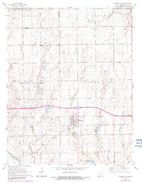
1965 Map of Garden Plain
USGS Topo · Published 1982About this map
Garden Plain serves as the central hub for this mid-1960s landscape, characterized by the grid-patterned fields of the Garden Plain and Grand River terrain. The Atchison Topeka and Santa Fe railroad cuts a diagonal path through the southern sections, anchoring the local economy to the rail network. Small rural clusters like St Joe and St Marys appear alongside religious and community landmarks such as St Anthony Cem and Calvary Cem.
Find a feature on this map
23 named features on this map. Tap any name to fly to it.
Don’t see what you’re looking for? This feature index may not catch every label — zoom into the map to look around manually.
Map Details
Editions of this 1965 Garden Plain Map
2 editions found
Other maps of this area

1889 · Cheney
USGS Topo · 1:125,000

1891 · Cheney
USGS Topo · 1:125,000

1901 · Cheney
USGS Topo · 1:125,000

1955 · Wichita
USGS Topo · 1:250,000

1958 · Wichita
USGS Topo · 1:250,000
1958 · Colwich
USGS Topo · 1:24,000

1959 · Mount Hope
USGS Topo · 1:24,000

1964 · Cheney
USGS Topo · 1:24,000

1965 · Garden Plain
USGS Topo · 1:24,000

1965 · Cheney SE
USGS Topo · 1:24,000