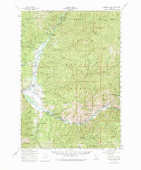
1959 Map of Garden Valley
USGS Topo · Published 1975About this map
The confluence of the Middle Fork Payette River and the South Fork Payette River centers this mid-century survey of the Boise National Forest. The map documents the scattered settlements and administrative outposts of the era, including the village of Crouch and the Garden Valley Ranger Sta. To the south, the terrain transitions into an active mining district near Mineral Mtn, where the Golden Age Mine, Grand View Mine, and various Mineral Mines are recorded alongside the small community of Grimes Pass.
Find a feature on this map
84 named features on this map. Tap any name to fly to it.
Don’t see what you’re looking for? This feature index may not catch every label — zoom into the map to look around manually.
Map Details
Editions of this 1959 Garden Valley Map
2 editions found

Other maps of this area

1892 · Boise
USGS Topo · 1:125,000

1894 · Squaw Creek
USGS Topo · 1:125,000

1894 · Idaho Basin
USGS Topo · 1:125,000

1897 · Boise
USGS Topo · 1:125,000

1909 · Garden Valley
USGS Topo · 1:125,000

1953 · Smiths Ferry
USGS Topo · 1:62,500

1953 · Boiling Springs
USGS Topo · 1:62,500

1953 · Banks
USGS Topo · 1:62,500

1953 · Deadwood Reservoir
USGS Topo · 1:62,500

1955 · Baker
USGS Topo · 1:250,000