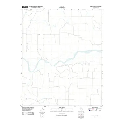
2010 Map of Garden Valley
USGS Topo · Published 2010About this map
Prairie Dog Town Fork Red River meanders across the center of this 2010 landscape, carving a wide bed through the ranch land of Childress County. This USGS study reflects the vast drainage networks of the Texas Panhandle, where seasonal tributaries like Buck Creek, Setters Creek, and Soldiers Creek feed into the larger river system. A network of county roads, including Co RD 18 and Co RD K, crisscrosses the high plains, providing access to isolated rural properties. For genealogists, the map preserves the exact location of the Olympus Cemetery, a significant local landmark situated north of the river near Co RD L. The area is sparsely settled, defined by large agricultural tracts and a grid of secondary roads such as Co RD P and FM 1033, illustrating the persistent rural character of this border region near the Oklahoma state line.
Find a feature on this map
16 named features on this map. Tap any name to fly to it.
Don’t see what you’re looking for? This feature index may not catch every label — zoom into the map to look around manually.
Map Details
Editions of this 2010 Garden Valley Map
This is the sole edition of this map. No revisions or reprints were ever made.
Other maps of this area

1954 · Plainview
USGS Topo · 1:250,000

1955 · Lawton
USGS Topo · 1:250,000

1958 · Plainview
USGS Topo · 1:250,000

1960 · Goodlett
USGS Topo · 1:62,500

1960 · Loco
USGS Topo · 1:62,500

1961 · Hollis
USGS Topo · 1:62,500

1967 · Kirkland North
USGS Topo · 1:24,000

1967 · Childress
USGS Topo · 1:24,000
1975 · Hollis NW
USGS Topo · 1:24,000
1984 · Arlie
USGS Topo · 1:24,000