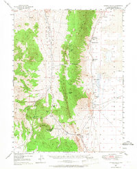
1949 Map of Garden Valley
USGS Topo · Published 1968About this map
Sulphur Spring Range dominates the central portion of this 1949 landscape, creating a physical divide between Garden Valley and the expansive Diamond Valley to the east. The map records a transition in local transportation and industry, specifically noting a Dismantled RR and the Mt Hope Mine (Inactive), which suggest a period of shifting economic activity in Eureka County. Ranching life is well-documented through numerous family-named homesteads like Siri Ranch, Sadler Ranch, and Romano Ranch, many of which were established near vital water sources like Shipley Hot Spring or the complex network of mountain springs.
Find a feature on this map
39 named features on this map. Tap any name to fly to it.
Don’t see what you’re looking for? This feature index may not catch every label — zoom into the map to look around manually.
Map Details
Editions of this 1949 Garden Valley Map
3 editions found
Other maps of this area

1926 · Roberts Mountains
USGS Topo · 1:250,000

1929 · Roberts Mountains
USGS Topo · 1:250,000

1934 · Jiggs
USGS Topo · 1:125,000

1937 · Mineral Hill
USGS Topo · 1:48,000

1937 · Jiggs
USGS Topo · 1:125,000

1943 · Mineral Hill
USGS Topo · 1:62,500

1949 · Garden Valley
USGS Topo · 1:62,500

1949 · Roberts Creek Mtn
USGS Topo · 1:62,500

1951 · Roberts Creek Mtn
USGS Topo · 1:62,500

1951 · Garden Valley
USGS Topo · 1:62,500