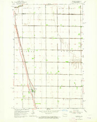
1963 Map of Gardena
USGS Topo · Published 1964About this map
The Great Northern railroad corridor serves as the primary spine for agricultural transport in this portion of the Red River Valley during the early 1960s. This survey, conducted just as modern infrastructure was expanding across the prairie, shows a major roadway Under Construction parallel to the tracks, signaling the transition from rail-centric to highway-based commerce. The landscape is dominated by the geometric precision of the township and range system, with the boundary between Traill Co and Cass Co bisecting the survey area near Grandin. The Elm River meanders through the northern sections, providing a natural break in the structured grid of rural townships including Kinyon, Noble, and Wiser. Focused on the small grain-handling centers of Gardner and Grandin, the map illustrates the distribution of farmsteads and the early stages of the interstate highway system reaching these North Dakota communities.
Find a feature on this map
12 named features on this map. Tap any name to fly to it.
Don’t see what you’re looking for? This feature index may not catch every label — zoom into the map to look around manually.
Map Details
Editions of this 1963 Gardena Map
This is the sole edition of this map. No revisions or reprints were ever made.
Other maps of this area

1950 · Upham SE
USGS Topo · 1:24,000

1950 · Willow City SW
USGS Topo · 1:24,000

1954 · Omemee
USGS Topo · 1:24,000

1954 · Souris SE
USGS Topo · 1:24,000

1954 · Gardena
USGS Topo · 1:24,000

1954 · Willow City
USGS Topo · 1:24,000

1954 · Minot
USGS Topo · 1:250,000
1955 · Upham NE
USGS Topo · 1:24,000

1955 · Bottineau
USGS Topo · 1:24,000

1955 · Bottineau SE
USGS Topo · 1:24,000