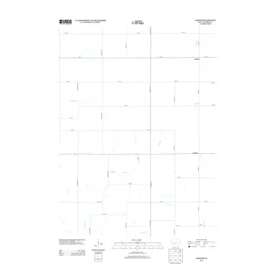
2013 Map of Gardner
USGS Topo · Published 2013About this map
The unincorporated community of Gardner serves as a central point in this rural landscape of Audubon County, where the grid of county roads is named for the bird life of the Midwest. Small settlement nodes such as Larland and Melville are positioned at the intersections of gravel routes like Pheasant Ave and Robin Ave, reflecting the persistent agricultural character of the region in the early 21st century. The terrain is defined by the winding paths of Davids Cr and its tributaries, including Crabapple Cr and Honey Cr, which break the regularity of the section lines. This 2013 survey provides a clear look at the persistence of established place names like Conkling in a part of Iowa where the vast majority of the land remains dedicated to farming and open space.
Find a feature on this map
27 named features on this map. Tap any name to fly to it.
Don’t see what you’re looking for? This feature index may not catch every label — zoom into the map to look around manually.
Map Details
Editions of this 2013 Gardner Map
This is the sole edition of this map. No revisions or reprints were ever made.
Other maps of this area

1954 · Omaha
USGS Topo · 1:250,000

1957 · Omaha
USGS Topo · 1:250,000

1957 · Audubon
USGS Topo · 1:62,500

1958 · Omaha
USGS Topo · 1:250,000

1971 · Coon Rapids South
USGS Topo · 1:24,000

1971 · Viola Center
USGS Topo · 1:24,000

1971 · North Branch
USGS Topo · 1:24,000

1971 · Gray
USGS Topo · 1:24,000
1971 · Adair North
USGS Topo · 1:24,000
1983 · Exira West
USGS Topo · 1:24,000