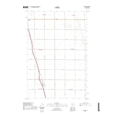
2020 Map of Gardner
USGS Topo · Published 2020About this map
The eastern North Dakota prairie is defined here by the sharp boundary between Traill Co and Cass Co, where the towns of Gardner and Grandin anchor a landscape of precise agricultural sections. This 2020 record of the Red River Valley hinterlands shows a transportation corridor dominated by Co Hwy 81, which runs parallel to the primary rail line, connecting the small grain-handling communities. In the southern portion of the map, the village of Gardner is centered at the junction of Front St and Cty Rd 26, with the Gardner Cem located just to the north. The survey illustrates the grid-based development typical of the region, where roads like 168 Ave SE and 12th St SE partition the flat terrain into large, productive farm tracts. Smaller wetlands and seasonal drainage patterns are scattered across the eastern edge, showing the natural hydrology that persists alongside extensive human cultivation.
Find a feature on this map
38 named features on this map. Tap any name to fly to it.
Don’t see what you’re looking for? This feature index may not catch every label — zoom into the map to look around manually.
Map Details
Editions of this 2020 Gardner Map
This is the sole edition of this map. No revisions or reprints were ever made.
Other maps of this area

1918 · Kelso
USGS Topo · 1:62,500

1918 · Hendrum
USGS Topo · 1:62,500

1943 · Kelso
USGS Topo · 1:62,500

1952 · Grand Forks
USGS Topo · 1:250,000

1956 · Grand Forks
USGS Topo · 1:250,000

1963 · Georgetown
USGS Topo · 1:24,000
1963 · Argusville
USGS Topo · 1:24,000

1963 · Perley
USGS Topo · 1:24,000

1963 · Gardner
USGS Topo · 1:24,000

1963 · Halstad
USGS Topo · 1:24,000