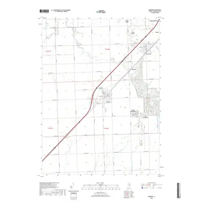
2018 Map of Gardner
USGS Topo · Published 2018About this map
Gardner sits at the center of this Grundy County landscape, where the prairie grid is interrupted by the diagonal paths of modern transport and the winding course of the Mazon River. The map documents a cluster of tightly spaced settlements including South Wilmington, East Brooklyn, and Braceville, which reflect the historic density of the local coal mining region. Near the northeastern corner, Central City and Godley border the edge of a landscape heavily shaped by industrial activity and waterway management, visible in the complex drainage patterns of Mazonia. Water management remains a defining characteristic of the area, with the West Fork Mazon River and East Fork Mazon River converging nearby, while smaller tributaries like Gooseberry Cr and Reddick Run drain the surrounding agricultural tracts. Local history is anchored by landmarks such as the Cotton Cem, situated just north of the Braceville town site.
Find a feature on this map
36 named features on this map. Tap any name to fly to it.
Don’t see what you’re looking for? This feature index may not catch every label — zoom into the map to look around manually.
Map Details
Editions of this 2018 Gardner Map
This is the sole edition of this map. No revisions or reprints were ever made.
Other maps of this area

1892 · Morris
USGS Topo · 1:62,500

1892 · Wilmington
USGS Topo · 1:62,500

1918 · Wilmington
USGS Topo · 1:62,500

1918 · Morris
USGS Topo · 1:62,500

1923 · Herscher
USGS Topo · 1:62,500

1925 · Herscher
USGS Topo · 1:62,500

1948 · Dwight
USGS Topo · 1:62,500

1950 · Dwight
USGS Topo · 1:62,500

1953 · Morris
USGS Topo · 1:24,000

1953 · Coal City
USGS Topo · 1:24,000