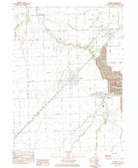
1983 Map of Gardner
USGS Topo · Published 1983About this map
Mine Dumps and extensive strip-mined landscapes define the eastern half of this Grundy County area, illustrating the heavy industrial legacy of the Illinois coal fields. These scarred terrains contrast sharply with the rectilinear agricultural grid that dominates Maine and Garfield townships to the west. The Illinois Central Gulf railroad serves as the primary spine of the region, connecting the residential centers of Gardner, Braceville, and South Wilmington. Smaller communities like Central City and East Brooklyn sit at the edges of these excavated zones. The natural hydrology is still visible through the winding course of the Mazon River and the East Fork Mazon River, which navigate between the mines and the farm roads. Local landmarks like Cotton Cem and the Matteson Landing Strip provide specific points of interest for genealogists and local historians tracking the development of these prairie settlements.
Find a feature on this map
33 named features on this map. Tap any name to fly to it.
Don’t see what you’re looking for? This feature index may not catch every label — zoom into the map to look around manually.
Map Details
Editions of this 1983 Gardner Map
This is the sole edition of this map. No revisions or reprints were ever made.
Other maps of this area

1892 · Morris
USGS Topo · 1:62,500

1892 · Wilmington
USGS Topo · 1:62,500

1918 · Wilmington
USGS Topo · 1:62,500

1918 · Morris
USGS Topo · 1:62,500

1923 · Herscher
USGS Topo · 1:62,500

1925 · Herscher
USGS Topo · 1:62,500

1948 · Dwight
USGS Topo · 1:62,500

1950 · Dwight
USGS Topo · 1:62,500

1953 · Morris
USGS Topo · 1:24,000

1953 · Coal City
USGS Topo · 1:24,000