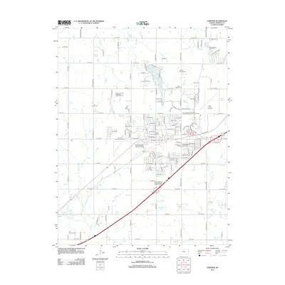
2012 Map of Gardner
USGS Topo · Published 2012About this map
Gardner Lake and the surrounding suburban and agricultural landscape of Johnson County define this 2012 survey. The area shows significant aviation and public infrastructure, centered around Gardner Municipal Airport and the expansive New Century Aircenter. Local history and genealogy are anchored by several established burial grounds, including Saint Columbia Cem, Four Corners Cem, and Gardner Cem. The map reveals a transition from the structured residential grid and civic spaces like the Johnson County Fairgrounds to the natural drainage of Kill Cr, Bull Cr, and Little Bull Cr. This modern edition also details the regional utility network, marking several specialized wastewater treatment facilities that serve the growing community, while recreational spaces like the Prairie Highlands Golf Course and Gardner Golf Course provide open green space amidst the expanding road network.
Find a feature on this map
124 named features on this map. Tap any name to fly to it.
Don’t see what you’re looking for? This feature index may not catch every label — zoom into the map to look around manually.
Map Details
Editions of this 2012 Gardner Map
This is the sole edition of this map. No revisions or reprints were ever made.
Other maps of this area

1885 · Lawrence
USGS Topo · 1:125,000

1887 · Olathe
USGS Topo · 1:125,000

1889 · Lawrence
USGS Topo · 1:125,000

1893 · Olathe
USGS Topo · 1:125,000

1935 · Olathe
USGS Topo · 1:24,000

1943 · Olathe
USGS Topo · 1:31,680

1947 · Lawrence
USGS Topo · 1:250,000

1950 · Lawrence
USGS Topo · 1:250,000

1951 · De Soto
USGS Topo · 1:24,000
1951 · Eudora
USGS Topo · 1:24,000