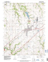
1991 Map of Gardner
USGS Topo · Published 1996About this map
The US Naval Air Station (Inactive) dominates the eastern landscape of Johnson County, reflecting a period of mid-century military transition. This survey highlights the spatial relationship between the town of Gardner and significant Cold War-era infrastructure, including the northern boundary of the Sunflower Ordnance Works. The terrain is defined by the headwaters of Kill Creek and Little Bull Creek, where agricultural land-use patterns intersect with early suburban expansion. For local historians, the map preserves the locations of several burial grounds, such as St Columbia Cem near the air station and the Fuller Cem further south. Notable civil aviation markers like the Gardner Landing Field and the recreational development around Gardner Lake illustrate the multifaceted growth of the area as it evolved from a rural rail-and-road junction into a more complex regional hub.
Find a feature on this map
20 named features on this map. Tap any name to fly to it.
Don’t see what you’re looking for? This feature index may not catch every label — zoom into the map to look around manually.
Map Details
Editions of this 1991 Gardner Map
This is the sole edition of this map. No revisions or reprints were ever made.
Other maps of this area

1885 · Lawrence
USGS Topo · 1:125,000

1887 · Olathe
USGS Topo · 1:125,000

1889 · Lawrence
USGS Topo · 1:125,000

1893 · Olathe
USGS Topo · 1:125,000

1935 · Olathe
USGS Topo · 1:24,000

1943 · Olathe
USGS Topo · 1:31,680

1947 · Lawrence
USGS Topo · 1:250,000

1950 · Lawrence
USGS Topo · 1:250,000

1951 · De Soto
USGS Topo · 1:24,000
1951 · Eudora
USGS Topo · 1:24,000