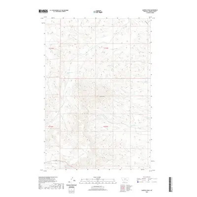
2020 Map of Garfield Peak
USGS Topo · Published 2020About this map
Garfield Peak dominates this Rosebud County landscape, rising amidst a complex network of drainage basins in the Ashland District. The topography is defined by the headwaters of numerous seasonal and perennial streams, including the north-flowing Greenleaf Cr and Bean Cr, and the eastward-draining Reservation Cr. This 2020 survey reveals the remote character of the region, where land use is marked by isolated water management features like Fields Reservoir and several named springs, such as the 01S43E31CACD01 Spring. The township and range lines of t1s r42e and t2s r43e provide a cadastral framework for this high-relief terrain. Modern infrastructure is sparse, limited primarily to Greenleaf Rd and primitive 4WD tracks that follow the ridgelines and valley floors, tracing a path through the drainages of Hollowbreast Cr and Burning Cr.
Find a feature on this map
24 named features on this map. Tap any name to fly to it.
Don’t see what you’re looking for? This feature index may not catch every label — zoom into the map to look around manually.
Map Details
Editions of this 2020 Garfield Peak Map
This is the sole edition of this map. No revisions or reprints were ever made.
Other maps of this area

1954 · Hardin
USGS Topo · 1:250,000

1957 · Hardin
USGS Topo · 1:250,000

1958 · Hardin
USGS Topo · 1:250,000

1958 · Garfield Peak
USGS Topo · 1:24,000

1958 · Fisher Butte
USGS Topo · 1:24,000

1958 · Badger Peak
USGS Topo · 1:24,000

1958 · Hollowwood Creek
USGS Topo · 1:24,000

1966 · Ashland
USGS Topo · 1:24,000

1966 · Ashland NE
USGS Topo · 1:24,000

1971 · Colstrip SE
USGS Topo · 1:24,000