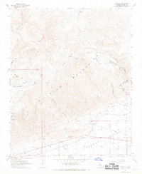
1967 Map of Garlock
USGS Topo · Published 1968About this map
Garlock sits at the southern foot of the El Paso Mountains, serving as a focal point where the desert floor of the Fremont Valley meets the mineral-rich uplands. This 1967 survey captures a landscape defined by small-scale mining and remote encampments, with the Southern Pacific railroad line and the Garlock Historical Marker indicating the area's significance as a supply and milling hub. The terrain is deeply etched by numerous canyons and gulches, including Last Chance Canyon, Goler Gulch, and Iron Canyon, many of which host specialized sites like the Burro Schmidt Tunnel and the Apache Mine. The distribution of scattered settlements such as Holland Camp, Colorado Camp, and Schmidt Camp reflects a transient yet persistent human presence tied to the extraction of resources from the surrounding peaks and the Black Hills to the northwest.
Find a feature on this map
54 named features on this map. Tap any name to fly to it.
Don’t see what you’re looking for? This feature index may not catch every label — zoom into the map to look around manually.
Map Details
Editions of this 1967 Garlock Map
3 editions found
Other maps of this area

1903 · Randsburg
USGS Topo · 1:62,500

1911 · Randsburg
USGS Topo · 1:62,500

1912 · Randsburg
USGS Topo · 1:62,500

1915 · Searles Lake
USGS Topo · 1:250,000

1943 · Inyokern
USGS Topo · 1:62,500

1943 · Saltdale
USGS Topo · 1:62,500

1947 · Trona
USGS Topo · 1:250,000

1948 · Trona
USGS Topo · 1:250,000

1953 · Ridgecrest
USGS Topo · 1:62,500

1953 · Trona
USGS Topo · 1:250,000