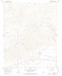
1967 Map of Garlock
USGS Topo · Published 1978About this map
Garlock stands as a focal point at the southern edge of the El Paso Mountains, where the desert terrain meets the Fremont Valley. This 1967 survey documents a landscape defined by its mining heritage and transit history, featuring the Southern Pacific railroad line and an Old RR Grade that traces earlier industrial movements. The presence of the Garlock Historical Marker near a cluster of wells and ruins indicates the area's recognized significance even during the mid-century. High in the hills and canyons, numerous extraction sites and temporary settlements are recorded, including Burro Schmidts Tunnel, the Apache Mine, and remote outposts like Holland Camp and Schmidt Camp. These features, connected by a network of jeep trails and canyons like Last Chance Canyon and Mesquite Canyon, reveal the persistent effort to tap into the mineral wealth of the Black Hills and surrounding gulches.
Find a feature on this map
46 named features on this map. Tap any name to fly to it.
Don’t see what you’re looking for? This feature index may not catch every label — zoom into the map to look around manually.
Map Details
Editions of this 1967 Garlock Map
3 editions found
Other maps of this area

1903 · Randsburg
USGS Topo · 1:62,500

1911 · Randsburg
USGS Topo · 1:62,500

1912 · Randsburg
USGS Topo · 1:62,500

1915 · Searles Lake
USGS Topo · 1:250,000

1943 · Inyokern
USGS Topo · 1:62,500

1943 · Saltdale
USGS Topo · 1:62,500

1947 · Trona
USGS Topo · 1:250,000

1948 · Trona
USGS Topo · 1:250,000

1953 · Ridgecrest
USGS Topo · 1:62,500

1953 · Trona
USGS Topo · 1:250,000