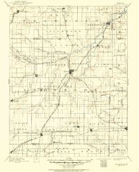
1894 Map of Garnett
USGS Topo · Published 1951About this map
Garnett sits at the heart of a dense nineteenth-century rail network where multiple divisions of the Missouri Pacific Railroad and the Atchison Topeka and Santa Fe R. R. converge. This survey reflects the agricultural and transit-driven development of eastern Kansas, showing a landscape partitioned into townships like Reeder, Washington, and Ozark. Small settlements including Mont Ida, Scipio, and Bush City are scattered along the rail lines, serving as critical loading points for the surrounding farms. The drainage of Pottawatomie Creek and its many tributaries, such as North Pottawatomie Creek and Cedar Creek, dictates the topography of the region. Notable landmarks such as Sugar Valley and the settlement of Blue Mound highlight the varied terrain found between the river valleys and the upland prairies.
Find a feature on this map
86 named features on this map. Tap any name to fly to it.
Don’t see what you’re looking for? This feature index may not catch every label — zoom into the map to look around manually.
Map Details
Editions of this 1894 Garnett Map
5 editions found

Other maps of this area

1884 · Fort Scott
USGS Topo · 1:125,000

1885 · Burlington
USGS Topo · 1:125,000

1885 · Garnett
USGS Topo · 1:125,000

1885 · Lawrence
USGS Topo · 1:125,000

1886 · Fredonia
USGS Topo · 1:125,000

1886 · Iola
USGS Topo · 1:125,000

1886 · Fort Scott
USGS Topo · 1:125,000

1887 · Olathe
USGS Topo · 1:125,000

1887 · Mound City
USGS Topo · 1:125,000

1889 · Burlingame
USGS Topo · 1:125,000