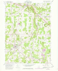
1959 Map of Garrettsville
USGS Topo · Published 1980About this map
The Mahoning River and Eagle Creek carve through this landscape at the junction of Portage, Geauga, and Trumbull counties. The topography is dominated by the dramatic rock formations at Nelson Kennedy Ledges State Park, which includes named landmarks like Kennedy Ledge and the nearby Lady of Fatima Ch. Settlement patterns show a mix of established village centers like Garrettsville and Parkman alongside smaller rural crossroads such as Pritchard and Soltis.
Find a feature on this map
82 named features on this map. Tap any name to fly to it.
Don’t see what you’re looking for? This feature index may not catch every label — zoom into the map to look around manually.
Map Details
Editions of this 1959 Garrettsville Map
Other maps of this area

1905 · Bristolville
USGS Topo · 1:62,500

1905 · Garrettsville
USGS Topo · 1:62,500

1906 · Ravenna
USGS Topo · 1:62,500

1907 · Bristolville
USGS Topo · 1:62,500

1907 · Garrettsville
USGS Topo · 1:62,500

1908 · Warren
USGS Topo · 1:62,500

1908 · Ravenna
USGS Topo · 1:62,500

1950 · Cleveland
USGS Topo · 1:250,000

1952 · West Farmington
USGS Topo · 1:24,000

1952 · Southington
USGS Topo · 1:24,000