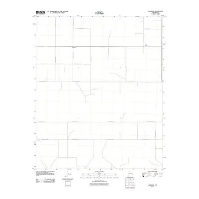
2010 Map of Garrison
USGS Topo · Published 2010About this map
Garrison serves as the central focal point of this high-plains landscape in Roosevelt County. The settlement patterns here follow a rigid, expansive grid of rural routes, primarily identified by a systematic county road network that includes S Roosevelt Road 27, S Roosevelt Road 30, and S Roosevelt Road 32. This geometric organization reflects the late 20th-century agricultural and ranching infrastructure of eastern New Mexico, where vast stretches of land are partitioned for efficiency and navigation.
Find a feature on this map
14 named features on this map. Tap any name to fly to it.
Don’t see what you’re looking for? This feature index may not catch every label — zoom into the map to look around manually.
Map Details
Editions of this 2010 Garrison Map
This is the sole edition of this map. No revisions or reprints were ever made.
Other maps of this area

1954 · Brownfield
USGS Topo · 1:250,000

1958 · Brownfield
USGS Topo · 1:250,000

1962 · Brownfield
USGS Topo · 1:250,000

1970 · Lingo
USGS Topo · 1:24,000

1970 · Causey East
USGS Topo · 1:24,000

1970 · Bledsoe NE
USGS Topo · 1:24,000

1972 · Bluit
USGS Topo · 1:24,000

1972 · Garrison
USGS Topo · 1:24,000

1972 · Milnesand
USGS Topo · 1:24,000
1972 · Pep
USGS Topo · 1:24,000