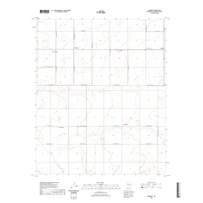
2020 Map of Garrison
USGS Topo · Published 2020About this map
Garrison and Causey anchor this section of the High Plains in eastern Roosevelt County, where the landscape is defined by a rigid grid of rural transport and agricultural boundaries. The township and range system is starkly visible through the numerous numbered routes, such as S Roosevelt Rd 27 and S Roosevelt Road 30, which partition the terrain into distinct sections. Near the eastern edge of the survey, the small community of Causey is served by Main St, while the nearby Causey Cem provides a focal point for local genealogical interest. The geography is characterized by subtle topographic shifts and small depressions, with roads like S Roosevelt Road 33 stretching across the southern expanse, illustrating the expansive, open nature of this New Mexico borderland region.
Find a feature on this map
21 named features on this map. Tap any name to fly to it.
Don’t see what you’re looking for? This feature index may not catch every label — zoom into the map to look around manually.
Map Details
Editions of this 2020 Garrison Map
This is the sole edition of this map. No revisions or reprints were ever made.
Other maps of this area

1954 · Brownfield
USGS Topo · 1:250,000

1958 · Brownfield
USGS Topo · 1:250,000

1962 · Brownfield
USGS Topo · 1:250,000

1970 · Lingo
USGS Topo · 1:24,000

1970 · Causey East
USGS Topo · 1:24,000

1970 · Bledsoe NE
USGS Topo · 1:24,000

1972 · Bluit
USGS Topo · 1:24,000

1972 · Garrison
USGS Topo · 1:24,000

1972 · Milnesand
USGS Topo · 1:24,000
1972 · Pep
USGS Topo · 1:24,000