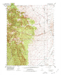
1949 Map of Garrison
USGS Topo · Published 1977About this map
Humboldt National Forest and the towering Snake Range dominate this 1949 survey of the Nevada-Utah borderlands. The landscape transitions from the high peaks of the forest down into the arid basins of the Burbank Hills, where human settlement clings to the few available water sources. The small community of Garrison serves as a local hub near the state line, supported by outlying properties like the Davies Ranch and Dearden Ranch.
Find a feature on this map
41 named features on this map. Tap any name to fly to it.
Don’t see what you’re looking for? This feature index may not catch every label — zoom into the map to look around manually.
Map Details
Editions of this 1949 Garrison Map
4 editions found
Other maps of this area

1908 · Fish Springs
USGS Topo · 1:250,000

1910 · Fish Springs
USGS Topo · 1:250,000

1948 · Wheeler Peak
USGS Topo · 1:62,500

1949 · Garrison
USGS Topo · 1:62,500

1950 · Wheeler Peak
USGS Topo · 1:62,500

1951 · Garrison
USGS Topo · 1:62,500

1953 · Richfield
USGS Topo · 1:250,000

1953 · Delta
USGS Topo · 1:250,000

1956 · Lund
USGS Topo · 1:250,000

1956 · Ely
USGS Topo · 1:250,000