
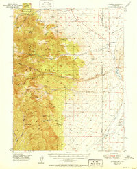
1951 Map of Garrison
USGS Topo · Published 1951About this map
The Nevada-Utah border divides this 1951 survey, where the high peaks of the Snake Range meet the arid expanse of Snake Valley. The small settlement of Garrison serves as a focal point near the state line, positioned between the rugged terrain of Lehman Caves National Monument to the west and Pruess Lake to the east. The map captures a landscape defined by water scarcity and ranching, with isolated outposts like Davies Ranch, Young Ranch, and Dearden Ranch scattered along the valley floor. Evidence of early aviation and infrastructure appears via the Landing Field and several windmills. Geologic and historical points of interest, including the Snake Creek Cave and the Burbank Cem, provide valuable landmarks for genealogists and local historians tracing the development of White Pine County during the mid-century.
Find a feature on this map
47 named features on this map. Tap any name to fly to it.
Don’t see what you’re looking for? This feature index may not catch every label — zoom into the map to look around manually.
Map Details
Editions of this 1951 Garrison Map
2 editions found
Other maps of this area

1908 · Fish Springs
USGS Topo · 1:250,000

1910 · Fish Springs
USGS Topo · 1:250,000

1948 · Wheeler Peak
USGS Topo · 1:62,500

1949 · Garrison
USGS Topo · 1:62,500

1950 · Wheeler Peak
USGS Topo · 1:62,500

1953 · Richfield
USGS Topo · 1:250,000

1953 · Delta
USGS Topo · 1:250,000

1956 · Lund
USGS Topo · 1:250,000

1956 · Ely
USGS Topo · 1:250,000

1958 · Richfield
USGS Topo · 1:250,000