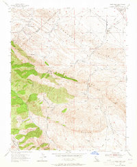
1953 Map of Garza Peak
USGS Topo · Published 1965About this map
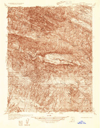
The Kreyenhagen Hills and Avenal Ridge dominate this mid-century landscape where Kings, Fresno, and Monterey counties converge. Early 1950s cultural revisions to the topography reveal a sparsely populated ranching and industrial corridor, where established holdings like Kreyenhagen Ranch, Clark Ranch, and Sagaser Ranch are interspersed with signs of the region's energy development. Abandoned oil wells and a Gravel Pit dot the terrain near Big Tar Creek, while the Pipeline Road cuts across the Kettleman Plain in the northeast. The map provides significant detail for local historians, documenting the location of the Boy Scout Camp near Tar Peak and the remote Dawson Mine along the western slopes. Natural water sources are critical features here, with Willow Spring, Dirty Spring, and Double Spring appearing as vital landmarks in the arid, high-elevation terrain of the Chalk Buttes.
Find a feature on this map
40 named features on this map. Tap any name to fly to it.
Don’t see what you’re looking for? This feature index may not catch every label — zoom into the map to look around manually.
Map Details
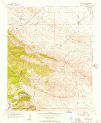
Editions of this 1953 Garza Peak Map
3 editions found

Other maps of this area

1912 · Coalinga
USGS Topo · 1:125,000

1914 · Cholame
USGS Topo · 1:125,000

1915 · Cholame
USGS Topo · 1:125,000

1917 · Cholame
USGS Topo · 1:125,000
1930 · Discovery Well
USGS Topo · 1:31,680

1930 · Canoas Creek
USGS Topo · 1:31,680

1930 · Kettleman Plain
USGS Topo · 1:31,680
1933 · Kettleman Plain
USGS Topo · 1:31,680
1934 · The Dark Hole
USGS Topo · 1:31,680

1934 · Reef Ridge
USGS Topo · 1:31,680