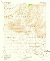
1952 Map of Gass Peak
USGS Topo · Published 1962About this map
Gass Peak dominates the center of this mid-century survey, looking down upon the evolving military and transportation corridors of the Las Vegas Valley. In the years following the war, this landscape became increasingly defined by federal activity, marked here by the expansive Nellis Air Force Base Gunnery Range and the Military Reservation Boundary. While the south shows the infrastructure of the Union Pacific railroad and the burgeoning Nellis AFB, the north remains a rugged expanse of high desert terrain. Local water sources like Mormon Wells and Quail Spring are meticulously recorded alongside geological features such as Fossil Ridge and the Sheep Range. Small-scale mining efforts are still evident through the June Bug Mine and several unnamed prospects scattered across the Desert Range.
Find a feature on this map
26 named features on this map. Tap any name to fly to it.
Don’t see what you’re looking for? This feature index may not catch every label — zoom into the map to look around manually.
Map Details
Editions of this 1952 Gass Peak Map
4 editions found
Other maps of this area

1886 · Saint Thomas
USGS Topo · 1:250,000

1893 · Saint Thomas
USGS Topo · 1:250,000

1907 · Las Vegas
USGS Topo · 1:250,000

1908 · Las Vegas
USGS Topo · 1:250,000

1926 · Boulder Canyon
USGS Topo · 1:96,000

1945 · Sheep Range
USGS Topo · 1:125,000

1952 · Corn Creek Springs
USGS Topo · 1:62,500

1952 · Gass Peak
USGS Topo · 1:62,500

1952 · Blue Diamond
USGS Topo · 1:62,500

1952 · Dry Lake
USGS Topo · 1:62,500