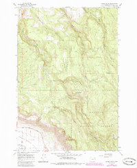
1965 Map of Gasset Bluff
USGS Topo · Published 1985About this map
Gasset Bluff overlooks the northern reaches of the Grande Ronde Valley, where the terrain rises sharply from the Grande Ronde River into the protected timberlands of the Whitman National Forest. This 1960s survey, updated in the mid-1980s, documents a landscape shaped by hydrology and forestry. The network of drainage is dense, featuring Indian Creek, Little Indian Creek, and the various forks of Clark Creek. Evidence of local industry and mountain management appears at the Gravel Pit and the Clark Creek Guard Station. Higher elevations are marked by landmarks like Grey Mountain, while access into the hills is maintained through a system of jeep trails and a pack trail following Camp Creek. Along the southwestern edge, the transition to the valley floor is traced by Lower Cove Road, connecting the upland forest to the agricultural lowlands.
Find a feature on this map
20 named features on this map. Tap any name to fly to it.
Don’t see what you’re looking for? This feature index may not catch every label — zoom into the map to look around manually.
Map Details
Editions of this 1965 Gasset Bluff Map
2 editions found
Other maps of this area

1906 · Telocaset
USGS Topo · 1:125,000

1955 · Grangeville
USGS Topo · 1:250,000

1959 · Grangeville
USGS Topo · 1:250,000

1964 · Cricket Flat
USGS Topo · 1:24,000

1964 · Minam
USGS Topo · 1:24,000

1964 · Elgin
USGS Topo · 1:24,000

1965 · Conley
USGS Topo · 1:24,000

1965 · Cove
USGS Topo · 1:24,000
1965 · Gasset Bluff
USGS Topo · 1:24,000
1965 · Imbler
USGS Topo · 1:24,000