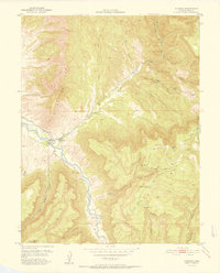
1952 Map of Gateway
USGS Topo · Published 1952About this map
The Dolores River cuts through a landscape of deep canyons and high mesas in this survey produced in cooperation with the United States Atomic Energy Commission. The settlement of Gateway serves as the focal point near the river's bend, where a Gaging Sta monitors the waterway. The area's industrial importance during the mid-century uranium boom is evidenced by the Vanaking No 1 Mine and the Mammoth Mine located among the tributary canyons. Terrain features such as The Palisade and Bull Hill define the vertical relief, while the Uncompahgre National Forest (Pine Mountain) covers the eastern high ground. This map captures the remote character of the Colorado-Utah border region before modern development, documenting seasonal outposts like Tenderfoot Camp and the winding Pickett Trail.
Find a feature on this map
40 named features on this map. Tap any name to fly to it.
Don’t see what you’re looking for? This feature index may not catch every label — zoom into the map to look around manually.
Map Details
Editions of this 1952 Gateway Map
2 editions found
Other maps of this area

1885 · La Sal
USGS Topo · 1:250,000

1949 · Juanita Arch
USGS Topo · 1:24,000

1949 · Calamity Mesa
USGS Topo · 1:24,000

1949 · Gateway
USGS Topo · 1:24,000

1950 · Juanita Arch
USGS Topo · 1:24,000

1950 · Calamity Mesa
USGS Topo · 1:24,000

1950 · Pine Mountain
USGS Topo · 1:24,000

1952 · Gateway
USGS Topo · 1:24,000

1954 · Mt. Waas 4 SE
USGS Topo · 1:24,000

1954 · Mt. Waas 4 NE
USGS Topo · 1:24,000