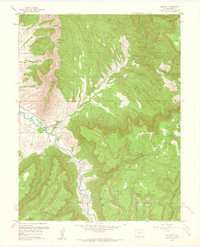
1960 Map of Gateway
USGS Topo · Published 1961About this map
The Dolores River cuts a deep path through this 1960 landscape, where the small settlement of Gateway serves as a lone hub at the junction of West Creek. This era of the Colorado plateau is defined by intense mineral exploration, evidenced by a concentration of uranium and vanadium operations such as the Vanaking No 1 Mine, Black Mama No 2 Mine, and the Protector Mine. The sheer verticality of the terrain is dominated by The Palisade, a massive formation overlooking the river valley. To the east, the Mesa rises toward the Uncompahgre National Forest, segmented by numerous drainages like North Larsen Canyon and South Larsen Canyon. Local life is anchored by the Wayside Chapel near the river, while industry reaches into the high country at the Mammoth Mine and Liberty Bell No 2 Mine.
Find a feature on this map
41 named features on this map. Tap any name to fly to it.
Don’t see what you’re looking for? This feature index may not catch every label — zoom into the map to look around manually.
Map Details
Editions of this 1960 Gateway Map
4 editions found
Other maps of this area

1885 · La Sal
USGS Topo · 1:250,000

1949 · Juanita Arch
USGS Topo · 1:24,000

1949 · Calamity Mesa
USGS Topo · 1:24,000

1949 · Gateway
USGS Topo · 1:24,000

1950 · Juanita Arch
USGS Topo · 1:24,000

1950 · Calamity Mesa
USGS Topo · 1:24,000

1950 · Pine Mountain
USGS Topo · 1:24,000

1952 · Gateway
USGS Topo · 1:24,000

1954 · Mt. Waas 4 SE
USGS Topo · 1:24,000

1954 · Mt. Waas 4 NE
USGS Topo · 1:24,000