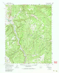
1960 Map of Gateway
USGS Topo · Published 1986About this map
The Dolores River cuts a deep, winding path through this corner of Mesa County, serving as the primary drainage for a landscape defined by massive mesas and extensive uranium mining activity. At the settlement of Gateway, the river meets Unaweep Canyon, while higher elevations like Tenderfoot Mesa and Outlaw Mesa are marked by a dense concentration of mining operations. The map provides a detailed look at the infrastructure of the mid-century mining boom, showing specialized worker housing at Calamity Camp and Climax Camp alongside numerous named shafts.
Find a feature on this map
79 named features on this map. Tap any name to fly to it.
Don’t see what you’re looking for? This feature index may not catch every label — zoom into the map to look around manually.
Map Details
Editions of this 1960 Gateway Map
4 editions found
Other maps of this area

1885 · La Sal
USGS Topo · 1:250,000

1916 · Paradox Valley
USGS Topo · 1:125,000

1922 · Paradox Valley
USGS Topo · 1:125,000

1948 · Roc Creek
USGS Topo · 1:24,000

1949 · Roc Creek
USGS Topo · 1:24,000

1949 · Juanita Arch
USGS Topo · 1:24,000

1949 · Atkinson Creek
USGS Topo · 1:24,000

1949 · Red Canyon
USGS Topo · 1:24,000

1949 · Calamity Mesa
USGS Topo · 1:24,000

1949 · Gateway
USGS Topo · 1:24,000