
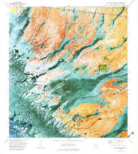
1973 Map of Gator Hook Swamp
USGS Topo · Published 1975About this map
Gator Hook Swamp and the surrounding Big Cypress wilderness are depicted here during the early 1970s, showcasing a landscape defined by seasonal water flow and cypress strands. The northern boundary of the map follows the vital Tamiami Trail and its parallel Tamiami Canal, which served as the primary east-west artery across the southern peninsula. Within this wetland mosaic, various linear cypress forests like Skillet Strand, Georges Strand, and Roberts Lakes Strand indicate the subtle drainage patterns toward the coast.
Find a feature on this map
17 named features on this map. Tap any name to fly to it.
Don’t see what you’re looking for? This feature index may not catch every label — zoom into the map to look around manually.
Map Details
Editions of this 1973 Gator Hook Swamp Map
2 editions found
Other maps of this area

1956 · Miami
USGS Topo · 1:250,000

1958 · Miami
USGS Topo · 1:250,000

1972 · Monroe Station NE
USGS Topo · 1:24,000

1972 · Big Boy Lake
USGS Topo · 1:24,000

1972 · Burns Lake
USGS Topo · 1:24,000

1972 · Ochopee
USGS Topo · 1:24,000

1973 · Pavilion Key
USGS Topo · 1:24,000

1973 · Monroe Station
USGS Topo · 1:24,000

1973 · Alligator Bay
USGS Topo · 1:24,000
1974 · Chokoloskee
USGS Topo · 1:24,000