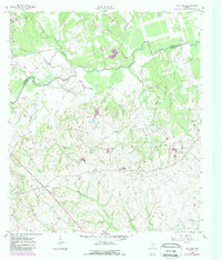
1959 Map of Gay Hill
USGS Topo · Published 1989About this map
The boundary between Burleson County and Washington County follows the winding course of Yeguacreek, defining a landscape of rolling creeks and agricultural plateaus during the late 1950s. This survey captures a rural Texas economy transitioning between traditional farming and industrial extraction, evidenced by the scattered Oil Wells and the concentrated activity within the Clay Creek Oil Field. The community of Gay Hill serves as a local anchor, while the Gulf Colorado and Santa Fe railroad provides the primary industrial artery for the region.
Find a feature on this map
29 named features on this map. Tap any name to fly to it.
Don’t see what you’re looking for? This feature index may not catch every label — zoom into the map to look around manually.
Map Details
Editions of this 1959 Gay Hill Map
Other maps of this area

1914 · Gay Hill
USGS Topo · 1:62,500

1930 · Brenham
USGS Topo · 1:62,500

1954 · Austin
USGS Topo · 1:250,000

1956 · Brenham
USGS Topo · 1:62,500

1956 · Somerville
USGS Topo · 1:62,500

1958 · Burton
USGS Topo · 1:24,000

1959 · Gay Hill
USGS Topo · 1:24,000

1959 · Clay
USGS Topo · 1:24,000

1959 · Somerville
USGS Topo · 1:24,000

1959 · Independence
USGS Topo · 1:24,000