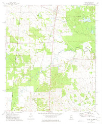
1973 Map of Geiger
USGS Topo · Published 1975About this map
Geiger sits at the northern edge of this West Alabama landscape, where the St Louis-San Francisco railroad cuts a diagonal path toward the Mississippi border. The terrain is defined by the winding course of Bodka Creek and its many tributaries, including Hatchet Creek, Tifallili Creek, and Quilby Creek. This 1970s survey captures a rural landscape rich with community landmarks, from New Mt Calvary Ch and Souls Chapel to the southern settlement of Winston. Genealogy researchers will find several points of interest, such as the Souls Chapel Cem and Jerusalem Ch, while evidence of changing infrastructure is visible in the Old Railroad Grade near Old Factory Creek. The presence of several Flowing Well labels suggests the importance of artesian water sources to the local agricultural and domestic life of Sumter County during this era.
Find a feature on this map
25 named features on this map. Tap any name to fly to it.
Don’t see what you’re looking for? This feature index may not catch every label — zoom into the map to look around manually.
Map Details
Editions of this 1973 Geiger Map
2 editions found
Other maps of this area

1929 · Epes
USGS Topo · 1:48,000

1932 · Epes
USGS Topo · 1:62,500

1953 · Meridian
USGS Topo · 1:250,000

1957 · Meridian
USGS Topo · 1:250,000

1965 · Meridian
USGS Topo · 1:250,000

1970 · Gainesville
USGS Topo · 1:24,000

1970 · Warsaw
USGS Topo · 1:24,000

1973 · Panola
USGS Topo · 1:24,000

1973 · Scooba
USGS Topo · 1:24,000
1973 · Geiger
USGS Topo · 1:24,000