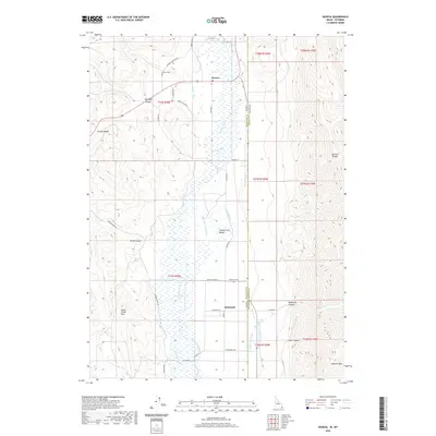
2020 Map of Geneva
USGS Topo · Published 2020About this map
Thomas Fork Valley serves as the central geographic feature of this borderland, where complex irrigation systems like the Steven Larson Ditch, Halls Ditch, and Etcheverry Ditch support the agricultural life of the basin. The settlement of Geneva sits near the northern edge of the map, while the community of Raymond is situated further south along the Idaho-Wyoming state line. This 2020 survey illustrates how the high-elevation terrain of the Preuss Range and the Sublette Range hem in the valley, dictating the placement of early travel routes and local infrastructure.
Find a feature on this map
46 named features on this map. Tap any name to fly to it.
Don’t see what you’re looking for? This feature index may not catch every label — zoom into the map to look around manually.
Map Details
Editions of this 2020 Geneva Map
This is the sole edition of this map. No revisions or reprints were ever made.
Other maps of this area

1909 · Montpelier
USGS Topo · 1:125,000

1911 · Montpelier
USGS Topo · 1:125,000

1936 · Cokeville
USGS Topo · 1:96,000

1942 · Cokeville
USGS Topo · 1:125,000

1955 · Preston
USGS Topo · 1:250,000

1958 · Preston
USGS Topo · 1:250,000

1962 · Preston
USGS Topo · 1:250,000

1967 · Huff Lake
USGS Topo · 1:24,000
1967 · Marse
USGS Topo · 1:24,000
1967 · Salt Flat
USGS Topo · 1:24,000