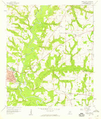
1957 Map of Geneva East
USGS Topo · Published 1959About this map
The confluence of the Pea River and Choctawhatchee River defines this corner of Alabama during the late 1950s, where the city of Geneva is protected by the Bridges Levee. The landscape is a complex network of waterways and drainage, with numerous named branches like Schuttle Mill Branch and Vanlandingham Mill Creek feeding into the main river systems. The town of Geneva shows its mid-century street grid, including Commerce St and Church St, while the Louisville and Nashville railroad tracks cut across the southern territory near the settlement of Black.
Find a feature on this map
51 named features on this map. Tap any name to fly to it.
Don’t see what you’re looking for? This feature index may not catch every label — zoom into the map to look around manually.
Map Details
Editions of this 1957 Geneva East Map
3 editions found
Other maps of this area

1942 · Enterprise
USGS Topo · 1:125,000

1949 · Hobbs Crossroads
USGS Topo · 1:24,000

1950 · Hobbs Cross Roads
USGS Topo · 1:24,000

1950 · Izagora
USGS Topo · 1:24,000

1950 · Esto
USGS Topo · 1:24,000

1951 · Esto
USGS Topo · 1:24,000

1953 · Dothan
USGS Topo · 1:250,000

1954 · Dothan
USGS Topo · 1:250,000

1954 · Tallahassee
USGS Topo · 1:250,000

1955 · Dothan
USGS Topo · 1:250,000