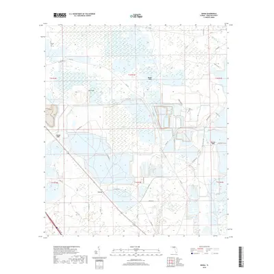
2018 Map of Genoa
USGS Topo · Published 2018About this map
Genoa sits at the convergence of several rural corridors in Hamilton County, serving as a focal point for the surrounding network of timber and turpentine-related sites. The presence of settlements like Blacks Still, Camps Still, and Purvis Still points to the historical importance of the naval stores industry in this part of Florida. The landscape is defined by its complex hydrology, where the Swift Creek Swamp and numerous "bays"—shallow, swampy depressions such as Bee Haven Bay and Black Bay—intersect with dry elevations like Pine Island and Hog Hammock. Genealogists can identify several local burial sites, including Barton Cem, Spring Branch Cem, and Poole Pond Cem, which are tucked away near water bodies and backroads. The map details a shifting terrain of wetlands and woodlands, traced by the winding path of Swift Cr and numerous county roads that linked these remote communities.
Find a feature on this map
54 named features on this map. Tap any name to fly to it.
Don’t see what you’re looking for? This feature index may not catch every label — zoom into the map to look around manually.
Map Details
Editions of this 2018 Genoa Map
This is the sole edition of this map. No revisions or reprints were ever made.
Other maps of this area

1954 · Valdosta
USGS Topo · 1:250,000
1955 · Jasper
USGS Topo · 1:24,000
1955 · Cypress Creek
USGS Topo · 1:24,000
1955 · Fargo SW
USGS Topo · 1:24,000
1958 · Valdosta
USGS Topo · 1:250,000
1959 · Valdosta
USGS Topo · 1:250,000
1961 · Live Oak East
USGS Topo · 1:24,000
1961 · Hillcoat
USGS Topo · 1:24,000
1961 · White Springs East
USGS Topo · 1:24,000
1961 · White Springs West
USGS Topo · 1:24,000