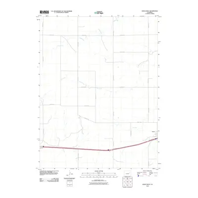
2010 Map of Genoa West
USGS Topo · Published 2010About this map
Genoa sits on the eastern edge of this Lincoln County landscape, where the High Plains terrain is etched by a series of intermittent drainages. The map reveals a strictly regulated surveyor's grid, with local transit following long-established routes like Old Hwy 24 and the modern Frontage Rd corridor. This transport network parallels the primary east-west highway, illustrating the transition from early auto trails to contemporary interstate infrastructure. Away from the settlement, the geography is defined by the winding paths of Lickdab Creek, Dugout Creek, and the curiously named Hell Creek. These watercourses create subtle topographical variations across the prairie, while a dense network of section-line roads, including County Rd-24 and County Rd-3N, provides access to the surrounding agricultural allotments.
Find a feature on this map
17 named features on this map. Tap any name to fly to it.
Don’t see what you’re looking for? This feature index may not catch every label — zoom into the map to look around manually.
Map Details
Editions of this 2010 Genoa West Map
This is the sole edition of this map. No revisions or reprints were ever made.
Other maps of this area

1891 · Limon
USGS Topo · 1:125,000

1892 · Limon
USGS Topo · 1:125,000

1954 · Limon
USGS Topo · 1:250,000

1957 · Limon
USGS Topo · 1:250,000

1958 · Limon
USGS Topo · 1:250,000

1970 · Limon
USGS Topo · 1:24,000

1970 · Four Corners
USGS Topo · 1:24,000

1970 · T Draw
USGS Topo · 1:24,000

1979 · Arriba NW
USGS Topo · 1:24,000
1979 · Barron Creek
USGS Topo · 1:24,000