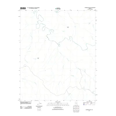
2011 Map of Georges Butte
USGS Topo · Published 2011About this map
The Black River winds through this high-country landscape in Navajo County, carving a deep, serpentine path that defines the northern half of the region. This 2011 survey reveals a remote landscape where water management is critical for land use, evidenced by a network of isolated reservoirs and tanks. Notable landmarks like Georges Butte and Round Valley anchor the geography, while drainages such as Lost Mule Creek and Deer Creek flow toward the primary river system. Transportation is limited to the winding path of Indian Rte 4 in the southeast corner. The presence of numerous named water catchments, including Pole Corral Tank and Steele Tank, suggests a history of livestock grazing and land management in this arid territory. This map serves as a primary record of the hydrological features and topography of the area during the early 21st century.
Find a feature on this map
19 named features on this map. Tap any name to fly to it.
Don’t see what you’re looking for? This feature index may not catch every label — zoom into the map to look around manually.
Map Details
Editions of this 2011 Georges Butte Map
This is the sole edition of this map. No revisions or reprints were ever made.
Other maps of this area

1954 · Clifton
USGS Topo · 1:250,000

1954 · Mesa
USGS Topo · 1:250,000

1957 · Mesa
USGS Topo · 1:250,000

1957 · Clifton
USGS Topo · 1:250,000

1958 · Clifton
USGS Topo · 1:250,000

1958 · Mesa
USGS Topo · 1:250,000

1960 · Mesa
USGS Topo · 1:250,000

1962 · Clifton
USGS Topo · 1:250,000

1964 · Mesa
USGS Topo · 1:250,000
1966 · Bronco Gulch
USGS Topo · 1:24,000