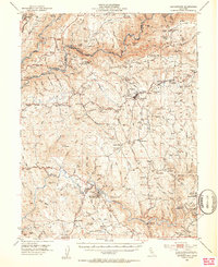
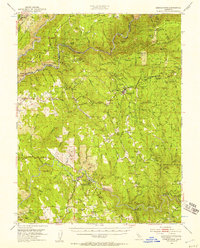
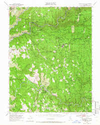
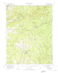
1949 Map of Georgetown
USGS Topo · Published 1953About this map
The California Mother Lode's legacy is central to this mid-century survey, specifically at Coloma, where the Gold Discovery Site State Historical Monument and the James W Marshall State Historical Monument mark the origins of the 1849 rush. The landscape is a network of mid-elevation ridge settlements like Georgetown and Greenwood and deep river canyons. The Middle Fork American River and South Fork American River cut through the terrain, flanked by historic river bars such as Buckeye Bar and Sardine Bar. Extensive mining evidence remains, from the Spanish Dry Diggings to numerous operations like the Argonaut Mine and Sliger Mine. The presence of several family-level burial grounds, including the Bowman Cem and French Hill Cem, provides vital points of interest for those researching local pioneer genealogy in El Dorado and Placer counties.
Find a feature on this map
125 named features on this map. Tap any name to fly to it.
Don’t see what you’re looking for? This feature index may not catch every label — zoom into the map to look around manually.
Map Details
Editions of this 1949 Georgetown Map
5 editions found

Other maps of this area

1888 · Smartsville
USGS Topo · 1:125,000

1891 · Sacramento
USGS Topo · 1:125,000

1891 · Colfax
USGS Topo · 1:125,000

1891 · Smartsville
USGS Topo · 1:125,000

1891 · Placerville
USGS Topo · 1:125,000

1892 · Sacramento
USGS Topo · 1:125,000

1892 · Placerville
USGS Topo · 1:125,000

1892 · Smartsville
USGS Topo · 1:125,000

1892 · Colfax
USGS Topo · 1:125,000

1893 · Placerville
USGS Topo · 1:125,000