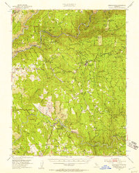
1949 Map of Georgetown
USGS Topo · Published 1957About this map
Gold-rush heritage defines the terrain along the forks of the American River, where this mid-century survey captures a landscape shaped by mineral extraction and early California settlement. The Gold Discovery Site State Park and James W Marshall State Monument near Coloma anchor the southern portion of the map, marking the 1848 discovery that transformed the region. Between the Middle Fork American River and the South Fork American River, the map reveals a dense network of mining claims such as Spanish Dry Diggings, the Argonaut Mine, and the Centennial Mine. Local community life is visible through landmarks like the Pilot Hill Grange, Canyon Creek Sch, and the Uniontown Cem. This era shows Georgetown as a central hub, surrounded by family-named landmarks and ridge-top settlements like Garden Valley and Greenwood.
Find a feature on this map
105 named features on this map. Tap any name to fly to it.
Don’t see what you’re looking for? This feature index may not catch every label — zoom into the map to look around manually.
Map Details
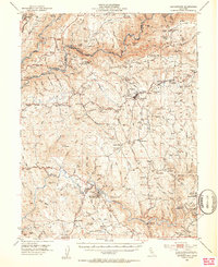
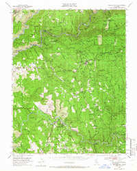
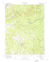
Editions of this 1949 Georgetown Map
5 editions found

Other maps of this area

1888 · Smartsville
USGS Topo · 1:125,000

1891 · Sacramento
USGS Topo · 1:125,000

1891 · Colfax
USGS Topo · 1:125,000

1891 · Smartsville
USGS Topo · 1:125,000

1891 · Placerville
USGS Topo · 1:125,000

1892 · Sacramento
USGS Topo · 1:125,000

1892 · Placerville
USGS Topo · 1:125,000

1892 · Smartsville
USGS Topo · 1:125,000

1892 · Colfax
USGS Topo · 1:125,000

1893 · Placerville
USGS Topo · 1:125,000