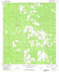
1982 Map of Georgetown
USGS Topo · Published 1982About this map
Georgetown serves as a central hub in this corner of Mobile County, where the convergence of Georgetown Road and Mason Ferry Road defines the local navigation. The landscape is deeply carved by a dense network of watercourses including Big Creek, Puppy Creek, and Sand Hill Creek, suggesting a terrain shaped by consistent drainage towards the coastal lowlands. Small settlements and family-named landmarks illustrate the rural character of the early 1980s, with Boothetown and several burial sites like Lott Cem and Byrd Memorial Cem anchoring the community history.
Find a feature on this map
42 named features on this map. Tap any name to fly to it.
Don’t see what you’re looking for? This feature index may not catch every label — zoom into the map to look around manually.
Map Details
Editions of this 1982 Georgetown Map
3 editions found
Other maps of this area

1941 · Creola
USGS Topo · 1:62,500

1942 · Kushla
USGS Topo · 1:31,680

1942 · Deer Park
USGS Topo · 1:62,500

1942 · Wilmer
USGS Topo · 1:62,500

1943 · Creola
USGS Topo · 1:62,500

1943 · Deer Park
USGS Topo · 1:62,500

1943 · Citronelle
USGS Topo · 1:62,500

1944 · Wilmer
USGS Topo · 1:62,500

1946 · Citronelle
USGS Topo · 1:62,500
1953 · Kushla
USGS Topo · 1:24,000