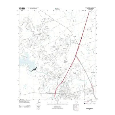
2013 Map of Georgetown
USGS Topo · Published 2013About this map
North Georgetown and the core of the city are defined by the convergence of the N Fork San Gabriel River and the Middle Fork San Gabriel River. This 2013 record documents the intricate street grids of the Belford Historic District and the University Avenue-Elm Street Historic District, illustrating the preservation of the town's architectural character amid regional growth. To the west, the massive footprint of the Lake Georgetown reservoir dominates the landscape at Russell Crossing, while the suburban expansion of Sun City and Serenada reflects the modern development of Williamson County. Critical local infrastructure, including the Produce Depot, the Georgetown Light and Water Works, and several aviation facilities like the Georgetown Municipal Airport, highlight the area's role as a regional economic and transit hub.
Find a feature on this map
255 named features on this map. Tap any name to fly to it.
Don’t see what you’re looking for? This feature index may not catch every label — zoom into the map to look around manually.
Map Details
Editions of this 2013 Georgetown Map
This is the sole edition of this map. No revisions or reprints were ever made.
Other maps of this area

1893 · Georgetown
USGS Topo · 1:125,000

1925 · Georgetown 4-b
USGS Topo · 1:48,000

1925 · Georgetown 4-d
USGS Topo · 1:48,000

1928 · Round Rock
USGS Topo · 1:62,500

1949 · Round Rock
USGS Topo · 1:62,500

1951 · Round Rock
USGS Topo · 1:62,500

1954 · Austin
USGS Topo · 1:250,000
1962 · Leander
USGS Topo · 1:24,000
1962 · Leander NE
USGS Topo · 1:24,000
1964 · Cobbs Cavern
USGS Topo · 1:24,000