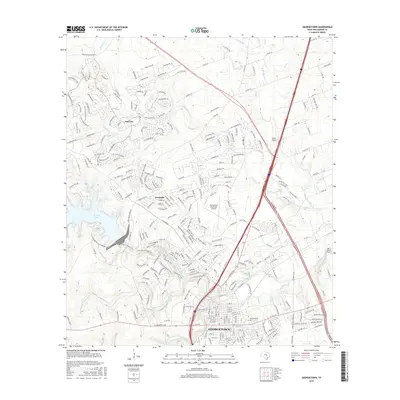
2016 Map of Georgetown
USGS Topo · Published 2016About this map
Georgetown sits at the confluence of the river forks that define the central Texas landscape, where the North Fork San Gabriel River, Middle Fork San Gabriel River, and South Fork San Gabriel River merge into the main stem of the San Gabriel River. This 2016 survey highlights the significant residential expansion north of the city center, particularly the massive Sun City development and the community of Serenada. Education and transportation infrastructure are prominent features, with the historic Southwestern University campus anchoring the downtown area while Georgetown Municipal Airport and Landry Airport serve the region's aviation needs. The western edge of the map is dominated by the North Fork Lake and its surrounding recreational trails, including the San Gabriel River Goodwater Loop. The map also captures local industry with a Gravel Pit located along the river's path, illustrating the area's geological and economic character.
Find a feature on this map
36 named features on this map. Tap any name to fly to it.
Don’t see what you’re looking for? This feature index may not catch every label — zoom into the map to look around manually.
Map Details
Editions of this 2016 Georgetown Map
This is the sole edition of this map. No revisions or reprints were ever made.
Other maps of this area

1893 · Georgetown
USGS Topo · 1:125,000

1925 · Georgetown 4-b
USGS Topo · 1:48,000

1925 · Georgetown 4-d
USGS Topo · 1:48,000

1928 · Round Rock
USGS Topo · 1:62,500

1949 · Round Rock
USGS Topo · 1:62,500

1951 · Round Rock
USGS Topo · 1:62,500

1954 · Austin
USGS Topo · 1:250,000
1962 · Leander
USGS Topo · 1:24,000
1962 · Leander NE
USGS Topo · 1:24,000
1964 · Cobbs Cavern
USGS Topo · 1:24,000