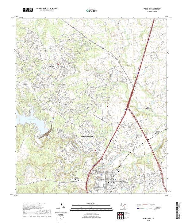
2022 Map of Georgetown
USGS Topo · Published 2022About this map
The Georgetown townsite is defined by the convergence of the North Fork San Gabriel River, Middle Fork San Gabriel River, and South Fork San Gabriel River. This modern survey documents the extensive residential expansion northward into Serenada and the planned community of Sun City. Despite this growth, the area’s history remains anchored by institutional landmarks such as Southwestern University and the Williamson County Justice Center. The landscape is a mix of suburban development and public works, dominated by the reservoir at Lake Georgetown to the west. For genealogists and local historians, the map identifies numerous small and historic burial sites, ranging from the Old Georgetown Cem and Odd Fellows Cem in the city center to the Green Family Cem and Berry Creek Cem on the outskirts.
Find a feature on this map
325 named features on this map. Tap any name to fly to it.
Don’t see what you’re looking for? This feature index may not catch every label — zoom into the map to look around manually.
Map Details
Editions of this 2022 Georgetown Map
This is the sole edition of this map. No revisions or reprints were ever made.
Other maps of this area

1893 · Georgetown
USGS Topo · 1:125,000

1925 · Georgetown 4-b
USGS Topo · 1:48,000

1925 · Georgetown 4-d
USGS Topo · 1:48,000

1928 · Round Rock
USGS Topo · 1:62,500

1949 · Round Rock
USGS Topo · 1:62,500

1951 · Round Rock
USGS Topo · 1:62,500

1954 · Austin
USGS Topo · 1:250,000
1962 · Leander
USGS Topo · 1:24,000
1962 · Leander NE
USGS Topo · 1:24,000
1964 · Cobbs Cavern
USGS Topo · 1:24,000