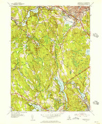
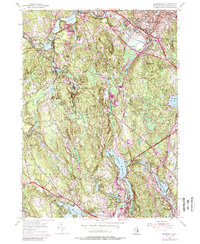
1954 Map of Georgiaville
USGS Topo · Published 1956About this map
Slatersville and the industrial corridors of the Woonasquatucket River define this mid-century portrait of northern Rhode Island. The landscape is a complex network of mill ponds and reservoirs, including the expansive Stillwater Reservoir and Georgiaville Pond, which powered the manufacturing centers of Spragueville and Esmond. At the northern edge, the urban density of Woonsocket meets more rural terrain where family-named landmarks like Keech Hill and Wionkhiege Hill rise above the valleys. The transportation infrastructure is dominated by the New York New Haven and Hartford railroad and historical thoroughfares such as the Douglas Turnpike. Local history is preserved through markers like The Shrine near Nasonville, several small burial grounds labeled Cem, and schools like the Andrews Sch, showing the social fabric of the townships during the post-war era.
Find a feature on this map
74 named features on this map. Tap any name to fly to it.
Don’t see what you’re looking for? This feature index may not catch every label — zoom into the map to look around manually.
Map Details
Editions of this 1954 Georgiaville Map
5 editions found
Other maps of this area

1886 · Blackstone
USGS Topo · 1:62,500

1887 · Franklin
USGS Topo · 1:62,500

1887 · Providence
USGS Topo · 1:62,500

1889 · Providence
USGS Topo · 1:62,500

1889 · Blackstone
USGS Topo · 1:62,500

1889 · Franklin
USGS Topo · 1:62,500

1889 · Burrillville
USGS Topo · 1:62,500

1893 · Franklin
USGS Topo · 1:62,500

1893 · Blackstone
USGS Topo · 1:62,500

1894 · Burrillville
USGS Topo · 1:62,500